Solo by Sea Canoe
July 2009
By Reinhard Zollitsch
Ten years ago I paddled along the entire south shore of the St. Lawrence from near Montréal, past Québec and around the big Gaspé peninsula back to New Brunswick, along the edge of the Appalachian Mountain Range. So I thought it might be fitting and interesting 10 years later to check out the north shore of the St. Lawrence, along the edge of the Laurentian Shield from Québec City to Tadoussac and then up the Saguenay Fjord to Chicoutimi, which I also had wanted to see for quite some time.

Click to enlarge map
As then, it was my birthday present from my family, my 70th now, and Nancy was again sweet enough to car shuttle me to my put-in in Québec and pick me up at Chicoutimi at the end of my trip. Thanks, my dear, I really appreciate it!

Start of trip (Québec/Lévis)
Part one: Down the St. Lawrence to Tadoussac
The summer of 2009 had been very wet, foggy, cold and windy and continued like that for the entire duration of my trip. I set up my boat on a tiny beach near the Lévis ferry to downtown Québec City between rain showers on the morning of July 22, 2009. The tide was just turning, which looked very promising for my downriver trip. As expected, though, crossing over the main arm of the river to Orléans Island and the north shore turned into my first test. I had to dance in the strong, breaking tidal rips caused by the 4-knot ebb stream and a strong 15-knot opposing NE wind. It got me wet for the rest of the day, but I felt good that I had not lost it over the winter and being 70 years old.
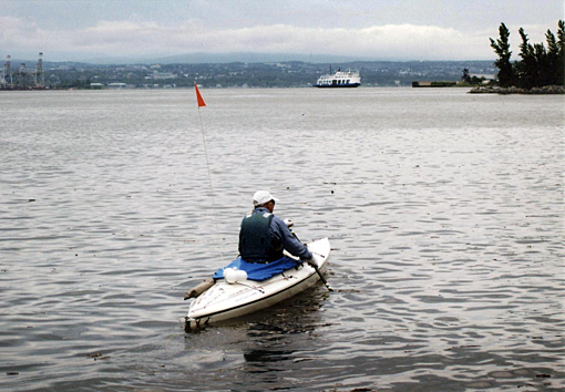
I am off (Québec/Lévis)
My goal for the trip was again about 20 nautical miles per day, or about 22.5 statute miles, following the shoreline, going point to point. After 6 hours, the shore at low tide, so it seemed, had moved farther and farther into the river. 1 to 2 mile wide mud or mostly rock flats extended out from the bank, making landing very difficult.
For my first overnight I therefore decided to ascend the St. Anne River near Beaupré, often lining my boat over the shallows. I thought I had finally found a spot above the high water mark, but when the tide came rushing back in, I had to break camp and move even higher up river, where I was able to pull out and pitch my little tent on someone's riverfront lawn. Fortunately for me, the owner did not mind.
The tides in the St. Lawrence
I knew then that taking out at the end of each day's paddle would be a problem all the way to Tadoussac, but that could not be helped – PORTAGE! Canadian canoeists seem to be very fond and proud of this character-building pastime, but not I. Anyway, the next day would take me through and around a large bird sanctuary along Cape Tourmente, the area where each Fall thousands of snow geese gather for their flight south. I saw none at this time of year, just a few Canada geese, ducks, terns and gulls and an occasional eagle or raven.
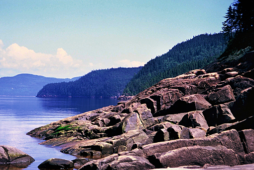
I kept paddling, hoping for a possible take-out, but there was none. Instead I saw miles and miles of extensive boulder fields and “rock gardens”. After 9:20 hours in my boat I finally found a steeper Maine-like shore at Cap de la Baie, at the mouth of St. Paul's Bay. I had gone 33.5 miles, my longest daily paddle ever. I was bushed, but still felt confident I could clamber up to the tiny, tent-sized brushy rock perch with my gear, but decided to let the slowly incoming tide carry my empty boat up there, about 18 feet.

Rocky perch (Cap de la Baie)
After my usual BDS (brief daily swim) and coffee as well as cocoa, I noticed I was right across from Îsle-aux-Coudres, which was named “Îsle-es-Couldres” by Jacques Cartier in 1535 (his second trip to the New World) after the many hazelnut trees (“couldres-coudriers”) there. The large island creates a sharp bend in the North Channel of the Seaway, forcing all ships real close by my shore. At night that bend was even illuminated with a string of lights marking the center line of the shipping lanes, just like on our freeways on shore.

Isle aux Coudres out my window
From my 1999 trip down the St. Lawrence I also remembered that the tides were not as regular as in New England, but that one high tide, mostly the morning tide, was one foot higher than the other. So I made sure I left myself a one-foot margin of safety for my camp. And sure enough, at 6:00 a.m. the tide was almost kissing my tent. Time to pack up and be gone, which was distinctly easier than landing here.
Fog and rain, and more rock flats the next day, till I reached the breakwater at St. Irénée, 24.5 miles downriver near the mouth of Malbaie Bay. There was a nice level pebble beach, which made portaging much easier than the day before, but it was still a very long, arduous haul to get my gear and boat up above the high tide mark.
On the edge
Strong wind warnings and a thunderstorm around supper time were the usual fare of my NOAA weather report, but I was off again at the usual 6:00 a.m.. The tide was ebbing very hard into Malbaie Bay, 3 knots on my chart, and I had to watch my step. But I could not possibly imagine what was waiting for me on the other side of the bay, at Cap-à-l'Aigle.
Before I realized what was coming, I was in it, and with the steep shores on my left, there was no way to get out. I was headed for a tidal rip the likes of which I had never seen, with humongous, steep and confused, 6-8' breaking waves. “OH NO!” I yelled, looking for the TV control to switch channels or turn off that darn machine. But life has no such control buttons. I was in it for dear life, fighting each wave as it broke over my deck, whomped me in the chest and even hit me big time in the face and over my head.
I was working feverishly to keep my boat running straight, accelerate over the crests, punch through the breaking tops and brace in anticipation of the slammers and side-slewers. And all that with only “half a paddle” a sea kayaker would say, a 50 inch, bent-shaft canoe racing paddle. But it was light - only 10 ounces - and I was quick, but very much on the edge, even more so than last year along the West coast of Newfoundland. But this time I could at least see what was coming – it was gnarly, menacing and downright scary, but I had seconds to get ready for each of the breaking waves.
It seemed I was caught in this tidal rip forever, till I finally managed to duck behind a ledge wall, which turned out to be the Cap-à-l'Aigle yacht club entrance. I breathed a big sigh of relief, mumbled a couple of thank-yous and pulled out on the beach just outside the breakwater. I was physically and mentally spent; I was done for the day after only 10 miles.
I even considered aborting my entire trip here. This trip was supposed to be a fun trip, I had told myself before I started - no nightmarish survival situations, I reminded myself. --- So I quietly beached my boat, bailed out, dried my clothes and tried to distract my mind with some easy, fun-reading by Clive Cussler and lots of hot chocolate.
I holed up for the rest of the day feeling very small. High wind warnings from the NE for the next day did not buoy my spirits either. However, I decided to wait making any drastic decision and see what tomorrow would bring.
Back in the saddle again
Thick fog, a gentle drizzle and a light easterly wind greeted me the next morning, and I was off again at the usual 6:00 a.m. I had to get back on my horse. I hated the thought of giving up. I only hoped “the eagle” of Cap-à-l'Aigle would not swoop down on me again. Instead I saw my first pod of white beluga whales while rounding Cap Saumon (Cape Salmon) when the fog lifted for a moment. They surfaced repeatedly off the big lighthouse on the point, while a small mink was swimming ashore, just feet away from my boat.
That made me smile again. I made it fine to the St. Siméon/Rivière du Loup ferry terminal and felt very accomplished. 3 miles further on I found a small gravel beach in Anse de la Ciboulette (Chives Bay), just before Pointe aux Quilles (Keel Point – I love those descriptive French place names). 20 miles in 5:20 hrs – I was back on my bucking bronco.

Rocks, rain and fog along the St. Lawrence
That afternoon I heard several mighty, deep-throated fog whistles of the huge bulk carriers and container ships steaming up and down the St. Lawrence Seaway. I never saw the big ships, even though I was so close, I could hear the breathy drop-off at the end of each whistle blow: “Whoah-aw!” More fog, rain and strong winds predicted for tomorrow. What else is new on the St. Lawrence? But I will make it to Tadoussac now. I was very confident.
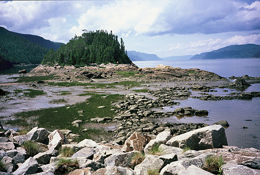
The rock flats, “battures”, of St. Catherine's Bay
My next big obstacle were the extensive rock flats (not mud flats) in St. Catherine's Bay just before the entrance to the Saguenay Fjord at Tadoussac. They are 7 miles long and extend 4 miles out into the river and are bone dry at low tide. And along its outer edge my chart indicated wicked tide rips. Crossing the “battures” needed careful planning; I was not going to be caught outside, for sure! I figured I had to get up even earlier and be on the water at 5:00 a.m. I would then have to buck the incoming tide for two hours, and paddle 3 hours of the ebb tide in order to cross the flats at half tide. That should work, I hoped.
The thick fog that morning posed an extra challenge, adding a lonely, eerie feeling to the run, but all worked out as planned. The incoming tide, however, was very strong again, so that I barely made it around Cap de la Tête au Chien (Doghead Point) and 2 more points (Raven and Basque Point). But I finally made it to Pointe Noire (Black Point), at the mouth of the Saguenay Fjord. By then it was ebbing so hard (7 knots according to my chart), I could not even make it up to the ferry dock.
I turned around and found a beach in St. Catherine's Bay, before that too ran dry.
More rain and thunderstorms in the afternoon. Ah well, I did not care, I had made it to Tadoussac! I looked at the harbor, which Jacques Cartier had visited in 1535 and which became the first European trading post in the new world (set up by Pierre de Chauvin in 1600). But I especially visualized Samuel de Champlain sailing up the fjord to Chicoutimi in 1608, hoping to find a route to “the saltwater sea up north”, James and Hudson Bay.
I also looked hard to see the “tadoussacs”, the two breast-like rounded hills the place was named for by the natives, but did not see anything resembling that female anatomy. I decided instead that early inhabitants as well as early sailors and traders must have been in the woods or at sea too long, and that this whole thing was nothing but wishful thinking. The Grand Tetons in the Rocky Mountains on the other hand...
Part two: Up the Saguenay Fjord to Chicoutimi
133 miles done, 75 more miles to go! What a sweet thought, provided the wind did not pipe up from the NW. The easterlies of the last couple of days would be nice, real nice, but please not 20-30 knots! Early the next morning I had to feel my way into the fjord with the flood tide. The fog was so thick I could not see the opposite shore. As a matter of fact, I had to steer a compass course from point to point whenever I was not directly touching the steep granite walls on my left.
At mile 10 the current turned and I was bucking a rather strong ebb tide, eddy-hopping from rock-outcropping to rock-outcropping in order to make it up to mile 23.5. As a matter of fact, the higher I paddled up the fjord, the more I noticed the warmer surface river water out of huge St. Jean Lake “ebbing” all the time, while the colder, heavier ocean saltwater must have been settling at the bottom of the deep fjord (up to 276 meters, about 830'), mostly just lifting the freshwater layer on the surface. So if I were to paddle the Saguenay again, I would definitely choose to paddle down from Chicoutimi to Tadoussac and not the way I was doing it now.
Looking up the Saguenay Fjord from Petit Saguenay
I had picked a small gravel beach/ramp at the Petit Saguenay River, just outside the national park, to be legal. There also was a public road to the point, and tourists were stopping by to admire the views all afternoon. “Wow! Look!” “Click” went the camera shutter, and moments later they drove off again.
Then two sea-doos and a couple of 4-wheelers, all driven by over-sized local youths, tore up the tranquility of this unique geological place. The engine noises reverberated mightily for a good 2 hours from the steep granite walls, while they churned up the quiet waters of the fjord or tore up the mud/rock flats. I had to stuff pieces of wet Kleenex into my ears and was eager to move on tomorrow.
My satellite phone worked flawlessly, though, even in the tight, steep-walled fjord. My new SPOT satellite GPS locator, on the other hand, was a disaster and never really worked. It was supposed to send my location to e-mail addresses of family members and friends at home, but all they and I got was a road map where X marks the spot. Each time I endlessly watched the little doo-hickey blink at me, but no real action, no real transmission. It took about 6-8 minutes to finally send the locator message. (What good would that do in a 911 emergency situation?!) “Tracking” did not work at all, not even as a locator. It goes back!
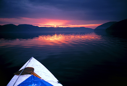
Sunrise over the Saguenay
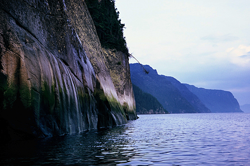
At 5:30 the next morning I saw my first sunrise of the entire trip. What a difference the sun makes! The fjord was calm and very still. Here and there a few fog clouds seemed to be hung up on the higher ridges and points along shore, rising in places to almost 500 meters (1,500 feet). Otherwise I saw mostly bare granite walls or steep slopes covered with very dense, green and narrow-shouldered spruces. There was hardly any deadwood as in our Maine woods.
Cap Éternité
I made it easily (for once) past Cap Éternité and Cap Trinité, maybe the most spectacular area of the entire fjord, to Anse du Gros Ruisseau (Big Brook Cove). I had chosen this spot because I expected a small sand or gravel beach or silt deposit at the outflow of the big brook. And I was right. Even better, the Park had established a few wooden platforms there for river travelers to camp on. I appreciated that, especially when I was hit with yet another thunderstorm and torrential rains in the late afternoon.

Cap Trinité
I again had a very early start without breakfast and a long portage to the water's edge, in order to catch what there was of the incoming tide. But as you know, I am a minimalist, and two granola bars on the run with plain water were just fine with me, as long as I could go with the flow.
The fjord was widening suddenly and the steep rock walls moved back somewhat and became lower, allowing houses to crowd in along shore. I had to smile when I crossed Ha! Ha! Bay. Last year I had camped at Ha! Ha! Point at another Ha! Ha! Bay in Newfoundland. This arm here would dead end at an industrial harbor, Port Alfred. (I had read that “Ha! Ha!” was derived from an old French word meaning “Dead End”, which would make sense in both instances.) My trip was distinctly winding down, as I entered the last arm to Chicoutimi.
More rocks and steep shores
I had one more overnight on a small pocket beach in La Grande Anse (The Big Bay). I arrived at about high tide and felt that my spot for my tent would allow even for the usual one foot tidal fluctuation of the St. Lawrence. But at 11:00 p.m., the waves were gently lapping against my tent, and the water was still rising. Gear bags, sleeping bag and pad as well as the entire set-up tent got tossed onto the rocks behind me, while I perched on a ledge in the moonlight, wearing my head net to ward off the mosquitoes. What a way to spend the last night of your trip, I thought to myself. At midnight, though, the tide had turned enough for me to move my tent and gear back to my old location. The night was short, but sleep came very easy.
The pick-up and happy encore
Only 12 more miles to Chicoutimi! No problem, no matter how bad the weather would get. I remembered the end of my 2007 trip from Lake Ontario to Québec, where I had left myself 21 miles for the last day and was hit by a 25-knot headwind. I almost missed my pick-up and my date with Nancy in the fancy hotel, the Chateau Frontenac. Did I ever work hard to get to that take-out spot!

Arrival in Chicoutimi
On this trip, 11:00 a.m. on July 31, 2009 was our target time to meet up at the public boat ramp at the Chicoutimi Yacht Club. I was right on time, and so was Nancy. What a wonderful sight that was: A smiling Nancy, camera in hand, and the car parked right beside the boat ramp. Hugs and kisses, a quick gear transfer, the boat on the roof rack...and off we were, back down to Tadoussac for a couple of days of happy R&R in the famous, traditional Grand Hotel Tadoussac.

Author at first trading post (Tadoussac)
And yes, we again visited the Chauvin/Champlain trading post, went in the picturesque little “Indian Church” and enjoyed the spectacular boardwalk from the harbor around Pointe de l' Islet to the fjord entrance. Even a few whales showed up to make this moment perfect.
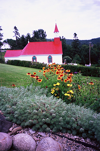
Old "Indian Church" in Tadoussac
Our return trip to Maine took us via ferry from St. Siméon, 15 miles across the St. Lawrence River to Rivière du Loup and on Canada's superhighways down to the crown of Maine and then back home to Orono. Another successful trip, consisting of 133 hard tide-ridden miles down the St. Lawrence with hardly any place to take out at low tide, and 75 spectacular miles up the Saguenay Fjord. 208 miles/333 km in 10 days – not bad for a 70-year old geezer, I thought to myself. But in the future I will try even harder to stay out of those nasty tidal rips...if only I knew where they would materialize. 100-200 yards of 6-8 foot breaking tidal waves are no fun, folks; believe me.
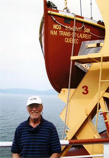
Crossing the mighty St. Lawrence to Rivière du Loup
Well, we'll see what next year brings.
Enjoy!
Ready to receive another trip sticker
INFO:
*Boat & gear: 17'2” Verlen Kruger SEA WIND sea canoe (www.krugercanoes.com)
*10 oz. carbon fiber bent-shaft marathon-racing canoe paddle by Zaveral (www.zre.com)
*NOAA paper charts for the entire area (no GPS)
*Iridium satellite phone (for daily safety check-ins at home – worked great, even in the steep fjord)
*SPOT, GPS locator (a disaster; “Tracking” never worked; a total waste)
*VHF radio telephone (for weather reports and contacting Coast Guard and other boats)
*Luneberg lensatic passive radar reflector by WEST MARINE (so I show up on other boats' radar)
*6-foot bicycle wiggle stick with orange flag (on stern; so other boats can see me better)
*Two 10 liter (2.5 gal.) water bags by MSR-DROMEDARY (enough water for the entire trip)
*Camping gear, including one-burner propane stove, and all canned foods etc. from home; for beach camping (no official campgrounds or marinas)
*Expenses: Food and propane tank from home; car shuttles;
R&R with Nancy: priceless!
*No sponsors – no stress, no obligation
© Reinhard Zollitsch
BACK TO TOP OF PAGE