Solo By Sea Canoe
by Reinhard Zollitsch
Champlain, 400 years later
Living in the northeast of the US it was hard not to notice that 2009 was the Henry Hudson as well as the Samuel de Champlain year, if you are interested in boating and early explorers, that is. While Hudson sailed straight north (!) up the Hudson River as far as Troy, NY in search of the Northwest Passage from the Atlantic to the Pacific Ocean (in 1609), Champlain had sailed southwest (!) up the St. Lawrence River as early as 1602, initially with the same goal as his French predecessor Jacques Cartier (in 1534/5). But Champlain soon changed his focus and put all his energy into establishing trading posts and minimal colonies in the new world. In 1600 the first fur trading post was established in Tadoussac, Québec, at the mouth of the Saguenay Fjord, about 130 miles downstream from Québec City (see my trip report in MAIB, Jan. 2010).
But to be successful, Champlain needed the cooperation of the native tribes along the St. Lawrence River. They unfortunately were in a bitter dispute with the Iroquois nation along the Hudson River and Lake Champlain. And here now begins our story.
To cement his trading treaties with the Montagnai and Algonquin people of the St. Lawrence, Champlain had agreed to help them fight their war against the Iroquois. So in 1609 Champlain and 11 men sailed up the St. Lawrence from Tadoussac to the mouth of the Iroquois/Richelieu River, just a tad downstream from Montreal, where they would join the native warring party.
From there they would go straight south for about 170 miles, up the Iroquois/Richelieu River and down Lake Champlain, to about where Fort Ticonderoga sits today. And since Champlain's heavy boats could not make it up the rapids of the river, they transferred to birch bark canoes. Champlain asked for volunteers and got two brave French sailors/soldiers to accompany him – whoopee! The remaining nine stayed with the heavy sailboats and the supplies. And so the war party of 60 men, including the three Frenchmen, set out in 24 canoes.
In order to keep the attack a surprise, they only traveled at night. But Champlain saw enough to comment on the lake and the surrounding mountains, even on plants and a “monster fish” (long-nosed gar) in the water. He liked what he saw and thus named the lake after himself. And if the Champlain Canal to the south had already been built and Champlain had traveled just a bit further, he would have bumped into Henry Hudson coming up from the south – what a historic coincidence that would have been!
The skirmish was decided by two shots fired from the two French guns, followed by the usual cruel burning, looting, maiming and killing, and then another long 170-mile paddle back to their sailboats waiting for them on the St. Lawrence. I wonder what would have happened if Champlain's powder had gotten wet or he and his fellow soldier had missed their target? In any case, I/we cannot ignore the fact that the whole trip was never designed as a peaceful, exploratory trip, like the one by Lewis and Clark out west (1804-06), and that the peace between the tribes did not last longer than a couple of years.
To me, the trip seemed like a very long, risky and cruel venture just to secure trading favors in the Tadoussac area. I am also disappointed that Champlain never returned to check out this big lake by day, at a later date, but rather chose to quest for the real Great Lakes, Georgian Bay off Lake Huron, that is. Many articles written for the quadricentennial celebration tried to whitewash the real intent of Champlain's trip down the lake. I grant you, that's better for tourism, but not historically accurate.
Lake Champlain, the sixth Great Lake?
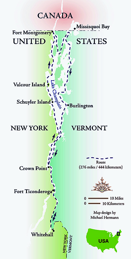
I had canoed north from Whitehall, NY into the St. Lawrence and beyond in 1999, but had never paddled around the entire lake, all 276 miles (444 km) of it. And since I like circumnavigations and like the ease of the car shuttle, and needed a break from tide-ridden, far-away coastlines, I decided 2010 was going to be my year on the big lake.
Click map to enlarge
And a mighty big lake it is (about 120 miles long and up to 12 miles wide). On March 6, 1998 President Clinton even declared it to be the sixth Great Lake (see attachment to Senate Bill # 927, National Sea Grant Program). However, its Great Lake's fame was short lived. On March 24, 18 days later, the vote was reversed, doubtless due to the five Great Lakes' unwillingness to share designated federal funding with the “newcomer”. But nothing changed the fact that Lake Champlain is still the sixth biggest lake in the US and shares much of the same geological history as the other five lakes.
In May 2010 I hoped the 400-year hoopla of 2009 was over. I had further decided to paddle the lake before Memorial Day, in order to avoid summer boat and people traffic, so that the lake was as uncongested and natural as possible.
Heading north through Dresden Narrows
As in 1999 and 2005, the traditional Finch and Chubb Inn at the Lock #12 Marina was again my point of departure, since I was able to leave my car there for the duration of my trip. It was May 18, 2010 as I pushed off before sunrise for my first 7 hr (26.5 miles) day to Five Mile Point, 5 miles north of Fort Ticonderoga, the first stop on the “Lake Champlain Paddlers' Trail” heading north.
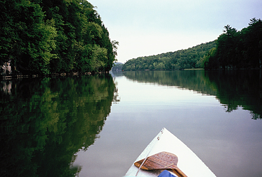
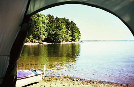
Lunch stop across from Fort Ticonderoga
I had joined the organization because I like the concept of a water trail, I support our Maine Island Trail (MITA) and the Hudson River Water Trail (HRWA), and I needed help finding legal overnight camping spots along the shores of Lake Champlain for my little Eureka tent. I found their Lake Champlain trail guide book quite helpful, but do not think everybody can push 26.5 miles or even more between stops, especially in a group. But then again, not everybody is paddling around the entire lake like I was, but mostly only loops onto it for a few days. I for my part made it around the entire lake without having to pull out on private land or being ousted, a great achievement on a popular lake bordering New York State and Vermont.
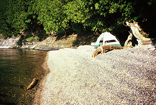
My first stop was just what I had hoped for – an almost level seawall of small, flat slate rock pieces off a point of rising shore. It required only minimal landscaping before pitching my tent right there at the water's edge. No portage and no tides to worry about, as I had on my last year's trip down the St. Lawrence to Tadoussac and up the Saguenay Fjord.
Day two started rainy and windy (N 10 knots), but clad in my Gore-Tex suit and hat, I made it fine to the narrows at Crown Point, which have turned into a major construction site. The old bridge is being replaced, and busy pontoon cranes, tug boats and two ferries cross the tight narrows below the old fort, while an over-sized statue of Champlain looks on. And then the wind cranked up in earnest, straight down the lake from the north, with a very long fetch. It blew a good 20 knots, and I had to dance in parallel breaking waves with foam streamers attached. Once I reached the NY shore at Port Henry, I was tempted to pull out and call it quits for the day, but I eventually clawed my way up along the steep NY shore, ducking behind every point, till I came to Northwest Bay and the even steeper shores of Split Rock Mountain. I had chosen Barn Rock Harbor, another Paddlers' Trail overnight stop. It was again a 27-mile paddle and took me 8 hours, including a few minimal breaks.
This area can be one of the most spectacular along the lake, but with a driving rain and my being stiff and tired from sitting in a small, bounding boat for 8 hours, I just set up my shelter, had a belated PB&J lunch and warmed up in my sleeping bag with coffee and cocoa cooked on my little one-burner propane stove right beside me in my tent – and it felt good.
Schuyler and Valcour Islands – it does not get much better!
The fog of the next morning burned off quickly as the sun came up, and a nice SE wind blew me past Essex and across Willsboro and Corlaer Bay to Schuyler Island, another official stop on the trail. The sun was fully out as I stepped ashore at 1:30 p.m. for a late lunch, a swim and some reading and writing my trip log. What a difference a day makes! My 5:00 p.m. safety check-in via satellite phone worked flawlessly as on previous trips, and talking with Nancy for 3 minutes wiped away all pain from the first two days – remember, I just turned 71!
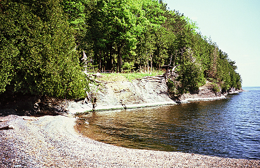
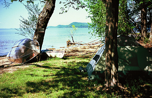
Pebble beach on Schuyler Island, NY
The noisy night-winds in the 7 huge poplar trees I had camped under calmed down almost completely in the morning. It was “A perfect day for banana fish” (remember the J. D. Salinger short story? I never knew what it meant, and I still don't, but it's a memorable title, don't you think?) as I paddled towards Valcour Island, where I stopped for lunch. In 1999 I had spent my fourth night here, so I was half a day ahead of my trip eleven years ago. It made me smile.
I noticed that the mountains north of Port Kent had moved back a bit, and the shore had gotten flatter, inviting lots of vacation homes to crowd right down to the water's edge. But I also noticed that I did not remember this developed shore at all from my previous trip. At first I feared my memory was failing me. And then it came to me: human habitations do not interest me on a canoe trip. I only take them in peripherally and turn my view towards the open water, the islands, distant peninsulas and the opposite shoreline, i.e. turn towards a cleaner, more natural horizon.

Cumberland Head light, NY
Since the weather was perfect, I headed straight across Cumberland Bay past Crab Island to the point of Cumberland Head, and from there across yet another bay, Tredwell Bay, to Long Point and into Conner Bay. The Paddlers' Guide describes an overnight beach “just north of a rocky point..in a beautiful grove of white cedars...” Well, I had a hard time finding it, not just because Conner was misspelled “Conners”. North of the distinct rock outcropping I found a breakwater and a large marina, but no beach and no cedars nowhere, nohow.
So I backtracked, and voilà, there it was: a thin stretch of sandy shore line tucked away just south of that rock outcropping, and in front of poplars, cut-leaf maples and a few ash trees; and all that in front of a murky and smelly mosquito pond. (I'll see to it that the guide book will be corrected.) By then I had spent another 8 hours in my boat and was tired, hot and hungry and needed to take care of those needs. By 5:00 p.m. I was a relaxed, normal citizen again, phoning Nancy.
Paddlers' Trail site in Conner Bay, NY
To and along the US/Canadian border
The western shore the next morning turned absolutely flat, like a big flood plane. This reminded me of what I had read about the history of Lake Champlain. From about one million to 12,000 years ago, a huge Pleistocene glacial icecap covered North America down to Long Island, NY. The weight of the mile-thick ice-shield deflected the earth's crust, allowing ocean water to fill the indentation when the ice finally melted and drained away to the north. Thus for a brief time Lake Champlain became an inland ocean arm off the mighty St. Lawrence, which explains why fossilized saltwater fishes and even beluga whales have been found in the sediments of the lake. Only Champ, a relative of the Scottish Loch Ness Monster, has not yet been found. So keep looking, folks! :-)
I made it to the Canadian border near Fort Montgomery, but then turned east, towards the Vermont side. Just before I reached the dual bridges, the old, low, broken down wooden one and behind it the elegant, much higher modern road bridge, I felt the pull of the flow out of the large lake into the Richelieu River and the St. Lawrence eventually. It was significant – watch it!
However, before I reached Missisquoi Bay (formerly known as Masipskiwibi, but Mrs. Quoi in my lingo) at the top right corner of Lake Champlain, I first had to scoot straight south for 13 miles and then 10 miles up again in a northeasterly direction to get around the long Alburg Tongue sticking out into the lake, like a big nasty tongue, of course. Two overnights later found me at the edge of the Missisquoi National Wildlife Refuge.
South along the Vermont side
I then had a wonderful time paddling straight south for 24 miles along the very pretty and mountainous side of Vermont to Sandbar State Park on the route #2 causeway to Grand Isle/South Hero Island. Brilliant sunshine made up for a light headwind, which at least kept me cool. Since it was before Memorial Day and the park was still closed, the resident ranger did let me camp there, after I helped him launch his rowing dinghy and gave him a hand into his boat.
Sandbar State Park, VT
A recent hip operation on one leg and knee operation on the other made that hard for him. He was a tough but kind old fellow, and we got along fine. (There is no camping allowed in the park, except for boaters in an emergency; normally day use only.)
I was glad I was again using accurate nautical NOAA charts, not road or hiking maps, because I had to get through the two dams/causeways to Grand Isle. On my chart both dams showed a low bridge (or opening in the latter dam) near the island. So I opted to follow the SE shore of the island and then paddle south again on the outside of the 3.25-mile long “Marble Dam” to Colchester Point.
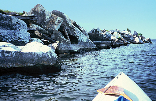
“Marble Dam” north of Colchester Pt., VT
I enjoyed stunning views both to the west (the NY shore) as well as to the east (the Vermont side), not to mention marveling at the highly unusual slabs of white marble in the dam itself. I noticed bikers on the former railroad dam. So I noted it down in my trip log as a thing to do for the future: take Nancy for a bike ride on “Marble Dam”. It's the closest thing to paddling this beautiful stretch of lake, and it's not too far from Burlington.
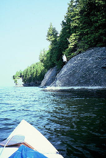
Striated rocks on Appletree Pt.
Big town Burlington, VT
Approaching Burlington wasn't half as bad as I had feared. The shoreline from the marble dam past the mouth of the Winooski River and around Appletree and Lone Rock Point was quite pleasant, as was the long granite breakwater of the harbor. I refilled one of my two 10-liter water tanks at a convenient marina and paddled on towards the tip of Shelburne peninsula, where I stopped for lunch on a lovely beach filled with stunning black and white striated rocks. Shelburne Bay behind it is one of the oldest natural harbors of the lake, with noble estates from the turn of the century and one of the oldest yacht clubs in the country. I found a secluded pocket beach with a steep shore behind me on the open lake side of this peninsula, not an official overnight stop, which I did not mind sharing with a group of raucous ravens.

Lone Rock Pt., approaching Burlington, VT
Next day took me 24 miles, almost straight south again, past a very pretty and very thinly settled Vermont shore with spectacular views of the opposite western shore of NY, especially the Split Rock Mountain range. I finally pulled out in Arnold Bay and wondered what exactly Benedict Arnold had to do with the name. He may have anchored his small fleet of boats here on his way to the battle of Valcour Island in 1776 with the British, or anchored what was left on the way back to Whitehall. :-(
Anyway, I got hammered here also - by a horrendous thunderstorm. I had to hold my tent up from the inside to keep it from buckling. Everything got wet inside, even my sleeping bag. Ah well, it'll dry tomorrow, me hopes.
Hideaway pocket beach, Shelburne, VT
The home stretch
Another 27-miler straight south, through the narrows at Crown Point and past Five Mile Point to another Paddlers' Trail site at East Creek, across from Fort Ticonderoga. The portage up the path to the edge of the slanting field, covered by 3-foot high rye grass, did not appeal to me, and I pitched my tent right at the mushy take-out. But I enjoyed a great view of the fort with Mount Independence to my left and a field of bulrushes to my right, while listening to a chorus of catbirds, mockingbirds, cardinals, orioles and many more.

East Creek
Several flocks of Canada geese flew noisily overhead, honking their way along this major north-south flyway. The local geese already had their 4-6 gangly goslings in tow. Thus the migrating flocks must have been non-breeding juveniles, I gathered. At night the bullfrogs were very vociferous.
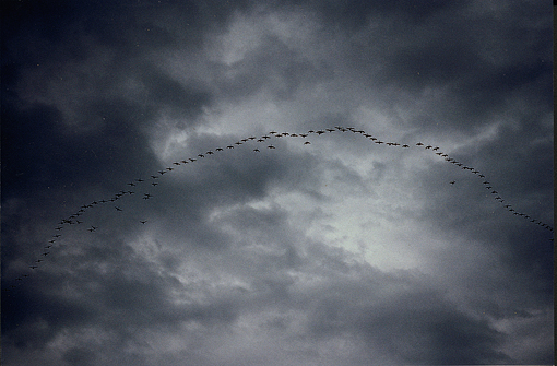
Migrating flock of geese
I had again planned in one wind day for the trip, but since I never felt I needed it, I had a rest day on my hands, since I did not want to drive home to Maine on the Saturday of Memorial Day weekend. This rest day was the hardest day of the entire trip for me. In all my previous trips, I had never taken off an entire day, and only had one severe wind day on the Baltic Sea. Since the weather was fine that morning, I was itching to get going, but I forced myself to sleep longer, have an extra mug of coffee and cocoa and finish reading the two books I brought along. I never took a nap, though. Maybe next year.
My last day on the water was somewhat anticlimactic. It was overcast with a light headwind, and the lake turned more into a tight river, which I already knew. It was Saturday, and only fishermen were out, some even in those super-fast bass-boats, barely touching the water as they sped along from one bend to the next.
I guessed there was a fishing tournament in progress, because everybody seemed to be in a real hurry to get to the right spot, get their lines in the water and watch and reel in their lines – totally mesmerized in their obsession. Only very few noticed me paddling by or said hello. And so ended my trip at the Lock #12 Marina and the Finch and Chubb Inn.

Lock #12 Marina
I found my car in perfect order where I had left it, washed my gear and boat, loaded up, took a shower and got dressed up for a celebratory dinner in house. The 370-mile trip home to Maine the next day, on a Sunday morning, was extremely smooth, as I had hoped it would be.
Summary
When I planned this trip I was looking for a break from my usual far-away, tidal ocean canoe trips, and I found just that. Lake Champlain is big, real big in places, and could dish out big waves in anything over 20-knot winds, especially when it blows from the north or the south. But lake winds only create wind waves, which never get exacerbated by a tidal flow, or worse, a tidal rip. There are also no big swells from distant storms superimposing themselves over the wind waves. When it blows on Lake Champlain, it gets rough in a hurry, but it also calms down quickly. This is the character of wind waves.
Fortunately, the NOAA marine weather reports are extremely accurate in this area, since the weather systems approach over land from the west, where there are plenty of observation stations, unlike Cape Breton Island or Newfoundland in the open Atlantic. Everything is much more predictable on this lake, except for the wild, erratic and noisy Sea-Doos, which have infected even these big waters. So make sure they see you or that you have an air horn handy.
So if you think you cannot handle the wind and waves of this lake at a specific point, get off the water and wait a while. It will get better in a hurry. And one more suggestion: If you do not like developed shore, look the other way, 12 miles across the lake at its widest point, to the 80 islands, significant peninsulas and distant shores. Long stretches of the almost 600 miles of shoreline are steep and natural, without a house in sight.
Here and there, though, the shore has been protected from erosion by big chunks of natural rock, often from quarries, ranging from granite to marble. They are the waste product of a former viable industry, cut-offs, culls, broken slabs, often still showing the drilled blast-holes. You get used to that.
All in all a very scenic, enjoyable and predictable 276-mile (444 km) circumnavigation of 25 miles per day (11 paddle days). Thanks to the tireless work of the Lake Champlain Committee, who put out the Lake Champlain Paddlers' Guide, you can now plan your trip with more confidence as to where you will be able to spend the night. I felt welcome on this lake and had fun. I'll be back some year.
**************************************
INFO:
NOAA marine charts # 14781-14784 (deLorme maps/atlas are OK for the surrounding shoreline)
The Lake Champlain Paddlers' Guide (www.lakechamplaincommittee.org)
free with membership)
H. P. Biggar: The Works of Samuel de Champlain (Voyages), Vol. 1. The Champlain Society, Toronto, 1922.
Wikipedia (on the web): Basic info on Lake Champlain
For Finch and Chubb Inn at the lock #12 marina, see www.visitwhitehall.com and finchandchubb@gmail.com
Gear:
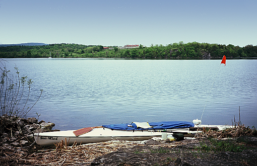
17'2” Kevlar Verlen Kruger SEA WIND sea canoe (www.krugercanoes.com)
Carbon fiber canoe racing paddle by Zaveral (www.zre.com)
Deck-mounted, passive radar reflector from West Marine and bicycle wiggle stick with orange flag (to enhance my visibility in any weather)
Beach camping gear with one-burner propane stove and all food from home
Two 10-liter water bags by Dromedary (with one refill)
No sponsors, no obligation, no stress!
************************
© Reinhard Zollitsch
BACK TO TOP OF PAGE