AND MOUNT DESERT ISLAND, MAINE
Stunning shorelines
Paddling around the Gaspé peninsula, around Cape Breton Island and up the western shore of Newfoundland were some of my most memorable and most spectacular trips in my 17-foot solo Verlen Kruger sea canoe. A close rival to those far-away venues, however, was one of my first trips ever, namely rounding Mount Desert Island (MDI) in my home state of Maine. It is so much more doable (only about 60 miles from my front door), and has vistas rivaling those areas mentioned above. To get the most of such a magnificent tall island like MDI with its many mountain peaks, I had learned over the years, one should not cling to the shoreline, as I did on my first trip, but view the island from some distance. So this time around I decided to skirt the outer perimeter of Frenchman Bay, to the north of MDI, and drop down to the Cranberry Isles, to the south of it as well. And what a spectacular 80-mile trip it turned into. Let me tell you all about it.
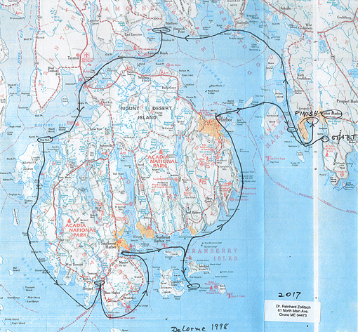
Click to open a larger version of this map
Each year in mid July I enter the Blackburn Challenge 20-miler around Cape Ann in Gloucester, Massachusetts (my 16th consecutive race this year in my solo outrigger canoe), but I can hardly wait to do my solo canoe camping trip somewhere along the Atlantic shores.
Four days after the always rough and tiring 4-hour race, I was all packed up and off to Frazer Point park on the Schoodic Peninsula for an early morning put-in on July 26. Unfortunately the tide was dead low, but I was able to "wheelie" my boat with most of my packs in it down to the water's edge. I had studied the tides in advance for each day I was going to be on the water and had carefully planned my put-ins and take-outs. Ten feet of tide are significant, which for most of my chosen overnight spots meant that I either could not land there because of the surrounding extensive mudflats and seaweed covered rocks, or take off the next morning. This is how it worked out.
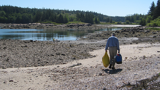
Low tide put-in (Frazer Point, Schoodic Peninsula)

I am off!
Rounding Frenchman Bay
Day one took me nicely with the flood tide, counter clockwise around the outer perimeter of Frenchman Bay, behind Ironbound, Jordan, Stave, Calf and Preble Island to Sorrento Harbor. A granola bar, a carrot and a small dish of applesauce were my lunch, washed down with plenty of water. The day had turned hot, and the wind was piping up from the south southwest, across the wide open bay. The air was crystal clear, the distant MDI mountain range stood out from the horizon as a stunning inky blue toothy line – just what I had hoped it would do. I had to take a picture of it, with Dram Island in the foreground, to give it the proper depth of perspective.
 MDI mountain tops as seen from Sorrento Hbr.
However, I could not linger long. Waves were beginning to break everywhere. The bay suddenly turned white, and my trip across to Hancock Point was getting very sporty. My weather radio spoke of 20-25 knot winds. It was there that I met another paddler – not a good place to stop and chat, I thought, but quickly learned he was heading for Lamoine Beach, while I was going a bit deeper into the bay to Marlboro Beach. However, he recognized me in my unique Verlen Kruger sea canoe and maybe by my still slight German accent, and was delighted to see me. "Nice to meet you, Reinhard," he shouted in my direction, as we got separated, dancing the by now significant waves. He looked like a confident paddler, and I was sure he would make it fine to his destination. I had enough to do to stay upright myself.
I had hoped to land for the night at the only deep water spot along the north shore of Marlboro Beach, but had no luck. There were only private places, mostly with a very steep shoreline. So I went deeper into the bay, knowing that tomorrow morning would be very difficult to get off. My chart showed that almost the entire bay runs dry. Well, that was too bad now! I had to land somewhere. High tide made that very easy. I found a small pebble beach just big enough for my tent. The next high tide at 2:00 am, though, would be very close, I figured, and it was – 2 feet from my tent door.
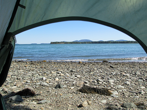 MDI mountain tops as seen from Marlboro Beach
But right now I enjoyed the high water, went swimming, did some writing and reading, pressed my SPOT locator beacon, as well as phoned Nancy on my satellite phone at 5:00 pm. The trip had begun, and as usual, it is never easy. I had to be sharp and work for it. Coffee and cocoa tasted good, though.
Into Blue Hill Bay
Low tide was at 8:42 this morning, and there was no way to get off my little sand/gravel spit before that. I figured I might be able to float off farther down my beach two hours after low, and I did. Fog and light rain changed to an overcast sky, which eventually cleared somewhat. The wind started light, 5-10 knots from the SW, but increased by the hour. Today would take me to the only bridge onto MDI. This big significant island, including Acadia National Park, is visited yearly by at least four million tourists. In 2016 the Park was especially busy, as it was celebrating its 100th birthday. This two-lane bridge is a real bottleneck for cars, trucks and RVs, but of course not for me in my canoe. It is a fixed bridge, allowing even small motorboats to pass under. The most important thing again is figuring the tide right: it floods very hard east to west, into Blue Hill Bay.
After a brief stop at the bathhouse in the Thompson Island park right at the bridge, I flushed under the bridge with conviction. But oh my! Blue Hill Bay was white! The wind was piping up through Bartlett Narrows with a vengeance, say 20-25 knots. I was in for a slugfest, which I did not really need at age 78 and only days after the hard Blackburn Challenge race. I clawed my way ever so slowly along the left shore towards Indian Point, till I finally found some shelter behind Green Island. I needed a break, some food, and especially water. Refortified, I set out to cross the last 1.2 mile gap from High Head to The Hub, the tiny rock island north of Bartlett Island. It was a no mistake situation, dancing in parallel waves. But it felt good, still being able to master those conditions, all on my own.
Landing on The Hub, a Maine Island Trail Association (MITA) site, at high tide with nobody else there, was a delight, which coaxed a tired but proud "YES!" out of me. With renewed energy, I set up camp on the only tent spot on the island under the still ant-ridden old pine tree. But if you remember to zip your tent screens at all times, this is no problem. There even was some lush grass at the take-out (on the northern tip of the island) to rest my boat on. The three Rs came easy this afternoon: resting, reading and (w)riting. I had earned it today. Coming to think about it, this was some of the hardest paddling I ever had to do, in order to get anywhere.
 The Hub
I slept till sunrise at about 5:00 am, only there was no sun. The FOG was so thick, I could not even see Bartlett Island, a stone's throw away from my humble abode. I have no problem with that, especially since there was hardly any wind. High tide was at 3:18 am, and I figured I still would be able to get off this rock at half tide, i.e. at 6:18 am. And that remained the routine for the rest of my trip: up at 5:00, off by 6:00, with the tide getting better by almost one hour each day. But it also meant: pack up tent and all gear, portage everything to the boat, pack and set up the boat and push off, all on an empty stomach.
I am sorry to say, though, that this morning I had to slither my 65-pound boat over a smooth, gently sloping rock shelf and seaweed, before it floated off, without leaving too much white gelcoat on the rocks. Paddling in the thick o' fog with an easy to follow shoreline (even though you can't see it) is magical for me, doing it all by chart, compass and stop watch, the old-fashioned dead reckoning way. No, I still do not have (or want) a GPS system, which would tell me where I am and where I should be going. I want to figure that out myself and keep my mind busy and involved in my trip. Only a few lobster boats were tending their traps. They should see me on their radar screen, I thought confidently, since I have a high-tech Lunenberg lensatic passive radar reflector mounted on my deck.
Going down Bartlett Narrows to the south, inside of John and Folly Island without seeing either shore, was delightful, a perfect moment of ocean solitude. Then, approaching Moose Island, the sun began to burn off some fog and created something I had never seen before: a "fogbow", like a rainbow, only this time with more muted colors, shades of gray and varied lights. I got it on film, the right half as well as the left half of the "fogbow", and even the reflection of the bow on the almost calm surface of the water. What a sight!

"fogbow" off Moose Island (left side)

"fogbow" off Moose Island (right side)
The fog then hung around some more along the rocky shoreline, like long wafting strands of mermaid hair, illuminated from behind by the early rays of the rising sun. A real "National Geographic moment". It was mesmerizing – or was the fog getting to me? But ever so slowly the fog burnt off completely, allowing me to see deep into the next five bays, past Rumell Island and Goose Cove Rock, all the way into Bass Harbor eventually. Two porpoises were playing off Lopaus Point, before I turned into Bass Harbor proper, a real fishing, ferry (to Swans Island) and tourist harbor. My MITA overnight spot was on Sawyers Island off Anns Point. It was deep into the harbor, surrounded by extensive mudflats and a long rocky beach, which I knew in advance. Low tide had been at 9:30 this morning, an hour ago, since I had paddled today's 14 miles in 4.5 hours. When the tide had crept up to the rocky slope, I started portaging my gear to my campsite, which was nicely shaded and had a great view to the south into the harbor. I rested up from yesterday's hard paddle and got a lot of reading done. Life was good.
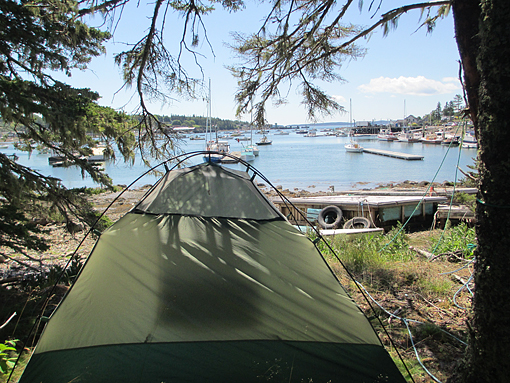 View into Bass Hbr. from Sawyers Island
Crossing the bar (literally, not in the sense of Alfred, Lord Tennyson)
The night was quiet and cold; I was wearing my polypropylene long underwear and wool socks in my sleeping bag. I was off again at 6:00, 2 hours after high tide, which was no problem. A beautiful sunrise made packing up at 5:00 a bit easier. But I did not like the weather forecast, speaking of northeast winds at 10-15 knots, which would be right on the nose for today's very exposed course. First, I had to cross the very formidable Bass Harbor Bar, which floods hard to the west and ebbs equally strong to the east. I had planned that right when I first considered my trip around MDI. I had just gotten my camera out to take a picture of the Bass Harbor Light, when the current took hold of me and almost blew me by it. To boot, the sun was right behind it, and I had to wait to get a good shot of the lighthouse. Then there was the very exposed corner into Western Way, with huge Long Ledge lurking at the turning point, not to mention the headwind.

Bass Hbr. Light
But stroke by stroke I made it around that obstacle and along the impressive seawall at Seawall, what else could you name this boulder shoreline. The deeper I got into the Western Way, which by now was ebbing significantly, making for very slow progress forward, I got into more and more civilized areas: large old mansions with fancy sailboats tied up to long wooden walkways towards deeper water, resting on criss-crossed granite slabs. The little town of Manset is the place where the most prestigious sailboats, the Hinckleys, are being built. The sailor in me was drooling, spotting some Bermuda 50s.
 View up Somes Sound
Most impressive, though, was the look up Somes Sound from here, flanked by rather tall mountains on both sides. For a moment I was tempted to paddle the 7 miles up the sound to Somesville, but decided against it, since it was ebbing strong and the wind was funneling down it, and I still had quite a ways to go to my next stop on Crow Island off the Cranberry Isles. Instead I tucked behind the Southwest Harbor breakwater and enjoyed my belated breakfast. Good decision!
Down to the Cranberry Isles
I then crossed over from the Coast Guard station to Greening Island and from there to Bear Island with its prominent lighthouse. It sits just outside of Northeast Harbor and looks very photogenic high up on a sheer cliff face. I took several pictures also, but noticed that the closer I got to it, the more it disappeared. My course then took me around Sutton Island and from there straight south along Little Cranberry Island's western shore, through The Gut to tiny Crow island, which is a MITA stop-over. Another 4-hour paddle for the day.
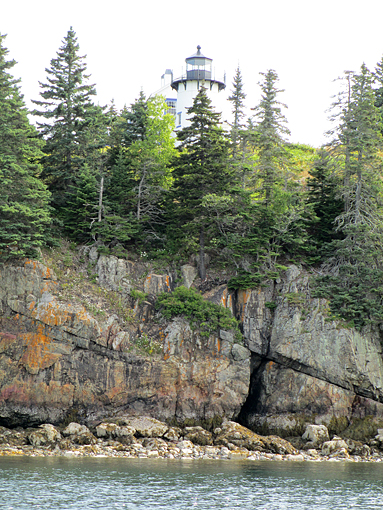
Bear Island Light
Again, nobody was there, and I could pitch my little Eureka on the only tent platform on the highest point of the island. There was no shade, but the view was spectacular. I had a panoramic view of the entire Mount Desert Island. I counted 12 mountain peaks, with the Cranberry Isles serving as a low, green foreground. Very impressive, and very worth all the hardship that I had encountered getting here. For you non-boaters out there, you can also take the ferry from Northeast Harbor to Islesford on Little Cranberry and enjoy this view as well as the friendly hospitality of this island.
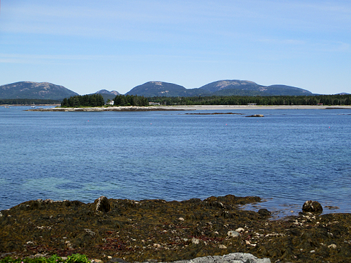 Bare MDI mountain tops as seen from Crow Island
When I arrived on Crow Island, I was able to drag my boat over seaweed to a level ledge, just high enough above the full tide. Since it turned into a hot day, I had to cool off frequently in the still quite cold Atlantic (barely 60°F). It never really warms up enough on these outer islands to enjoy a longer swim. And I make absolutely sure this does not happen "by mistake" from my boat.

Sunset over MDI mountain top skyline
Up the eastern shore of MDI
The last four days I had paddled about 15 miles in four hours each day, (in the Blackburn Challenge I do 20 miles in the same time, but in an empty, much faster boat). This day was going to be even longer (6 hours for 19 miles). But the shoreline was simply spectacular, but also very exposed. My weather radio mentioned winds from the NNE 10-15, i.e. again on the nose and a tad from the wide open Atlantic side – no shelter or helping hand from behind; another rough paddle ahead.
Well, I was off again without breakfast at 6:00 am, heading straight north via Sutton Island towards Seal Harbor. From there I just followed the steep shore around four major points: Western and Otter Point, Great and Schooner Head. It was a hard and often dicey paddle, especially negotiating the reverberating waves off the steep shore, but I clawed my way up towards the Bar Harbor breakwater and into the inner harbor. The big cruise ship, the Dutch Maasdam, which I had seen earlier this morning at sunrise from my perch on Crow Island, was already anchored behind Bald Porcupine Island, disgorging its passengers in several people-mover boats towards shore. The four-masted schooner Margaret Todd was about to push off with a load of tourists. I saw the boat later on the inner Frenchman Bay. Its full set of russet sails was very impressive.
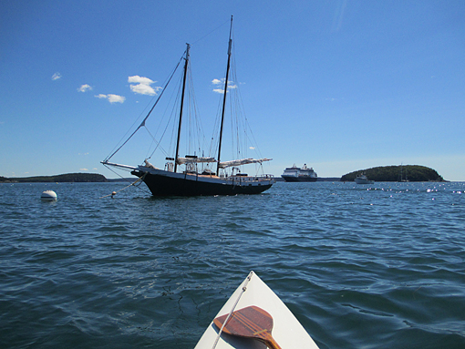
Classic and modern visitors to Bar Hbr.
I held onto the town float, and finally got to eat my belated breakfast. I had plenty of time to admire the huge (117 feet long) Sparkman & Stevens designed, ketch-rigged luxury yacht "Knickerbocker". I felt, though, a boat of that stature needed a name to match its opulence. "Knickerbocker" would only be acceptable to me, if the owner also owned the old Knickerbocker brewery, the Knickerbocker hotel on Times Square, NY, or the New York Knicks basketball team. The whole affair could then be a very pretty tax write-off, I mused. (It can also just mean "I am a proud New Yorker", Nancy informs me. She may be right.)
Be that as it may, after today's initial four hour stint in my little 17 footer, I was off for another 2 hours, island hopping across the entire Frenchman Bay. This took me past the Porcupine islands to the northern tip of Ironbound Island and from there straight south along Grindstone Neck to Little Crow Island, next to the slightly bigger Crow Island. Yes, another Crow Island. So today I paddled from one Crow Island (in the Cranberry Isles) to Little Crow Island, off Grindstone Neck. Both are MITA islands and are rarely visited, and even less so used for overnight camping. Little Crow is not much bigger at high tide than my 2-person tent. It is made up of ground-up shells with a few slightly higher rough looking granite ledges, where one could escape to, if bigger swells decided to roll in. I had camped here in 2006, when I did the entire Maine Island Trail from Cape Porpoise to Machias on the Canadian border. I loved it then and did again this year. The view across Frenchman Bay to MDI, specifically of Cadillac, Dorr and Champlain Mountain, is absolutely spectacular.
 Little Crow Island with MDI in background
Since Little Crow is the only MITA island around in this area, and since six hours of paddling 19 miles against the wind and an ebbing tide are more than enough, this was a perfect spot to stop. I also had to plan my take-out for tomorrow. It had to be near high tide, which was at 6:33 am. 8:00 am would still be OK at the Winter Harbor town ramp, I figured, which would save me the long up-hill haul at Frazer Point on the Schoodic Peninsula, where I had started my trip. "Could you make it there, dear Nancy and pick me up? Any time in the morning would be fine. I have some reading left for the wait..." As usual I phone Nancy at 5:00 pm every afternoon on my sat phone, as a kind of safety check-in. (No social call at $1.40 per minute, and no way to recharge my batteries).
Summary
And so ended my trip. I was just putting my boat down on the grass along the roadside when Nancy arrived at 7:00 a.m. sharp (yes, she got up real early in Orono, to make it down to Winter Harbor in time). "Thanks a million. I really appreciate it. You are a gem!"
 My most supportive fan and favorite pick-up girl, Nancy
And how was the trip, you readers might ask, as she did right then. Hard, but stunningly beautiful! Paddling around the big island on a trip is so different from putting in at Bartlett Narrows on a perfect day for an hour's paddle or two, or drifting down Somes Sound with the tide and a slight northerly, or rounding Bear Island from Southeast Harbor on a nice sunny day, just to mention a few popular day trips. No, when you are on a trip you are committed to what the weather dishes out, what the tides are doing and where you can camp for the night. Yes, out of my five full days of paddling, I had four really rough/challenging days. If you are bothered by fog (and I am not), the fifth day wasn't perfect either.
My idea of seeing MDI from slightly afar worked out perfectly. By going around the perimeter of Frenchman Bay, I got stunning views of the many mountain tops from the Sorrento area in the north, as well as from Crow Island in the Cranberry Isles in the south. And yes, I enjoyed yet another breathtaking view towards the mountains of MDI from the eastern shore of the bay, from my tiny last island post of Little Crow Island off Grindstone Neck. Three great viewing sites, one each from the north, the south and the east! Sorry, no views from the west; thick fog obscured all but the very shoreline.
Hope my pictures came out, but believe me, there is nothing like being there yourself! And that is the beauty of Mount Desert Island: it is beautiful close up, but also stunning from afar, as Samuel de Champlain must have seen the bluish silhouette of the many mountain tops when he sailed by here in 1604. And so he named this prominent, biggest island of Maine: "L'Isle des Monts-déserts", the island of the bare rocky mountain tops.
So, go see it! But boaters, be prudent. It is a big and very exposed island, with very hard, foreboding looking shores, in anything but the best of weather.
Enjoy and be safe!
Reinhard
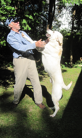
Willoughby: "Dad 's back!"
Reinhard Zollitsch
Orono, Maine
reinhard@maine.edu
www.ZollitschCanoeAdventures.com
![]()
Click here for a printable version of this article
************************
BACK TO TOP OF PAGE